
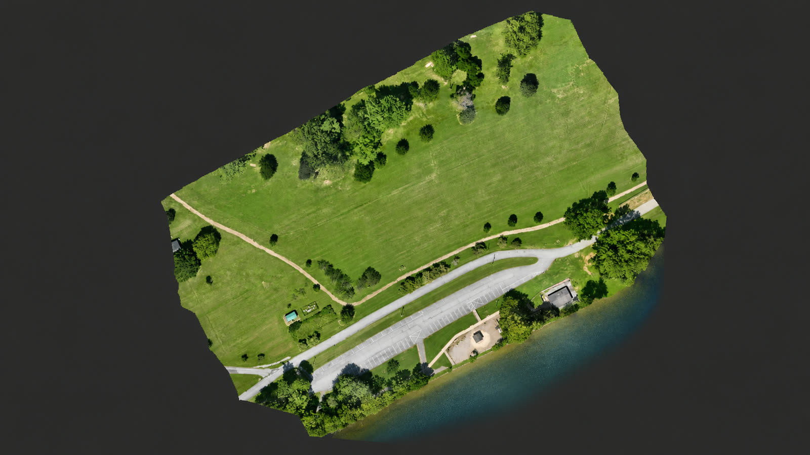
Orthomosaic
A full-resolution georeferenced site map a client can measure against and drop straight into their own documents.
Course 01TCAS Professional Deliverables Training
Built for Part 107 pilots who want to produce professional commercial deliverables — not just pass the test.
Practical workflow training from mission planning and D-RTK 3 field operations through DJI Terra processing, QGIS presentation, interactive web mapping, 3D reconstruction, Cesium, and iPad AR delivery. Part 107 teaches you the rules. TCAS teaches you the workflow. Capture real data. Process it correctly. Deliver something a client is willing to pay for.
TCAS training is for current FAA Part 107 certificate holders and commercial operators who need a practical path from capture to professional, client-ready deliverables. This is post-Part-107 professional skills training — not a Part 107 test-prep school and not basic recreational flight instruction.
Prelaunch: online checkout is not open yet. The complete 15-course Rev. 3 curriculum is written and finalized — join the launch list and we will email enrollment details, pricing confirmation, and availability the moment it opens.
How the Training Works
TCAS courses are based on workflows actually completed, tested, and documented from acquisition through final delivery. You follow the same sequence we use on completed TCAS field, processing, and delivery workflows, on your own site, with your own equipment.
Part 107 gives you legal operating authority. It does not teach you how to turn captured imagery into an orthomosaic, a classified point cloud, an elevation model, an interactive web map, a browser-ready 3D reconstruction, an AR presentation, or a professional client package. That gap is what this training closes.
Every course ends with a required deliverable and clear success criteria. If you cannot produce the output, you have not finished the course.
Each course targets one concrete finished product a client would accept.
Paid courses can include a TCAS Certificate of Completion. It is a course-completion credential documenting the workflow you finished and the deliverable you produced — it is not an FAA certificate, surveying license, engineering credential, or any regulatory or professional certification.
Workflow PDFs, printable checklists, project-folder templates, and troubleshooting notes you keep and reuse — released with each course at launch.
Deliverables
Every course targets a finished, client-ready product — not a tour of buttons in software. These are outputs TCAS has produced and delivered on real projects.
A full-resolution georeferenced site map a client can measure against and drop straight into their own documents.
Course 01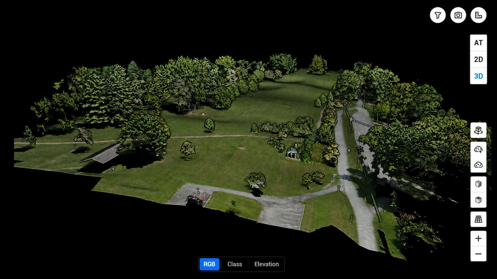
A quality-checked photogrammetric point cloud exported in the formats downstream professionals actually accept.
Course 02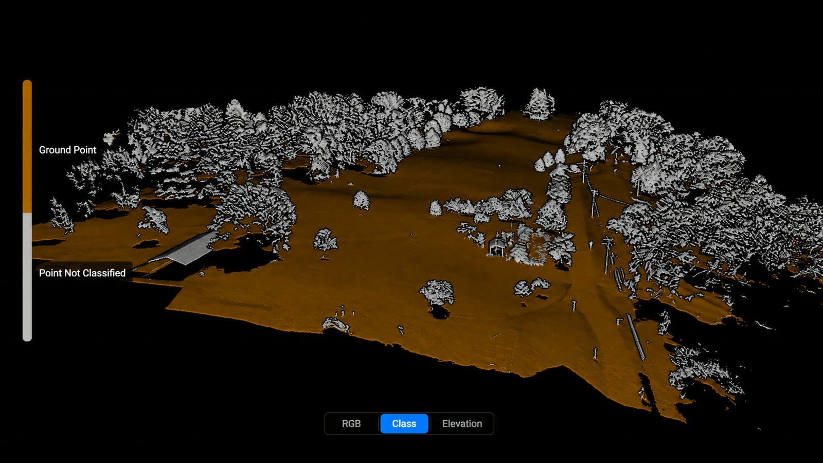
Ground separated from vegetation and structures, with the limitations of the classification clearly understood.
Course 03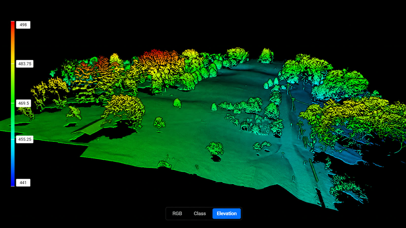
A georeferenced elevation surface delivered with the correct guardrails on what it can and cannot be used for.
Course 04A polished high-resolution presentation sheet built from the preserved geospatial master, not a screenshot.
Course 05A browser-tested interactive map package the client can pan, zoom, and share without any software install.
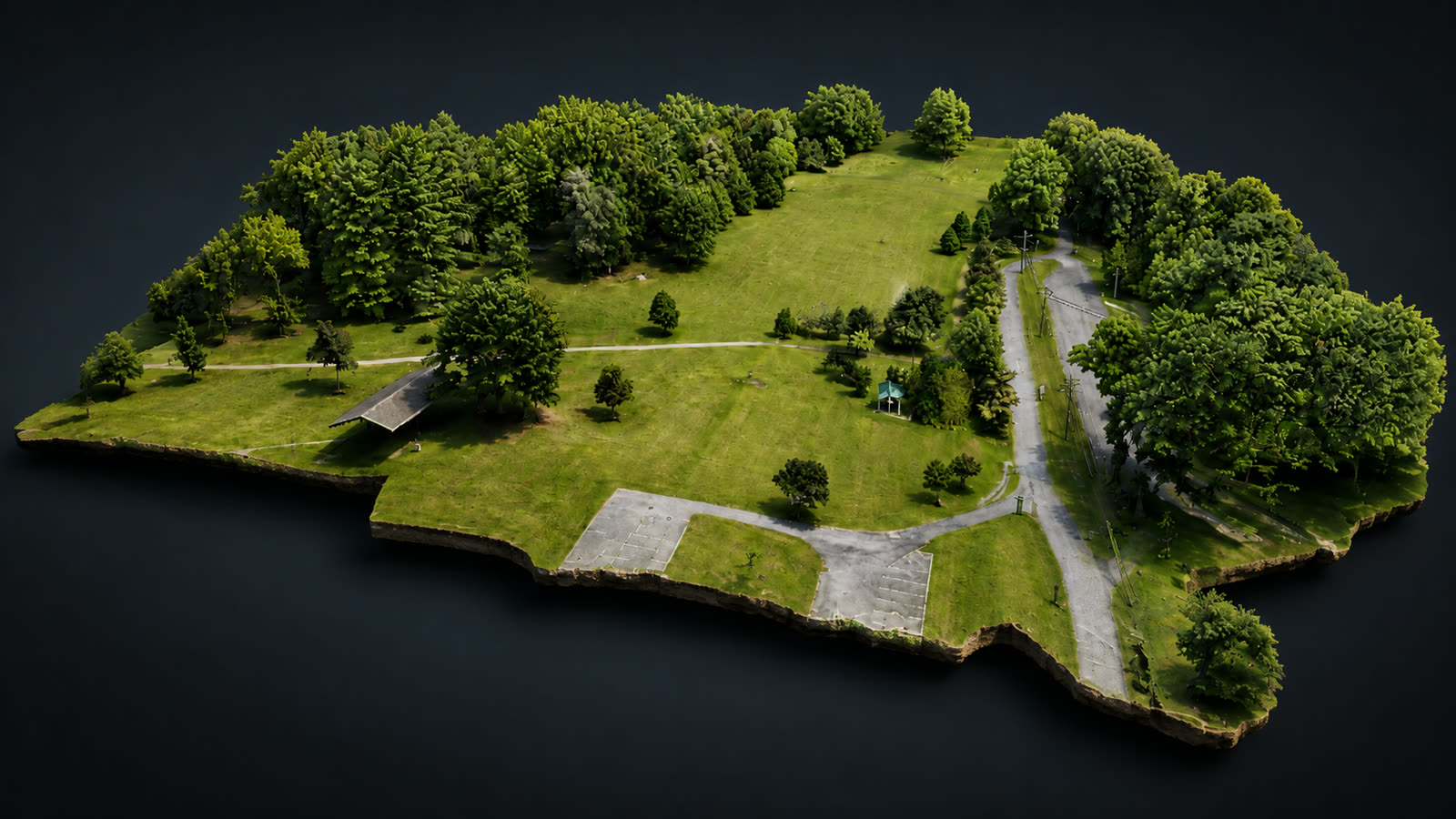
Course 06A textured 3D reconstruction with the model, texture, and companion data organized for real delivery.
Course 07An optimized web-ready model that loads and performs on a client's phone, tablet, and desktop.
Course 08A correctly oriented, cropped, and scaled AR model tested on Apple devices before it reaches the client.
Course 09A geographically positioned 3D presentation tested in the browser and on tablet for client walkthroughs.
Course 10A premium Terra mesh and High-density point cloud from one Smart 3D mission, both passed through separate documented QC gates.
Course 15What Makes This Different
This is not a Part 107 study course and it is not basic flight instruction. It is repeatable commercial workflow training aimed at finished deliverables.
The same sequence on every job: plan the mission around the deliverable, capture it once, process it correctly, check it, and package it for the client.
A large share of the instruction is troubleshooting: altitude reference confusion, terrain-follow problems, degraded acquisitions, RTK status misreads, and processing results that look fine but are not.
Orthomosaics, point clouds, terrain and elevation products, QGIS presentation sheets, interactive web maps, browser 3D, AR, and georeferenced 3D presentation.
Why This Training
What separates a workflow training system from a stack of tutorials.
Every course follows a workflow TCAS has actually completed, tested, and documented on real sites — from acquisition through final delivery.
Where TCAS has verified exact settings on a documented run, you get them exactly as run — parameter by parameter.
Reference values are labeled as reference values. Site- and job-dependent settings are taught as decisions to make, never as universal presets.
Each deliverable has explicit release criteria. If the output does not pass the gate, it does not ship — and the course is not complete.
The troubleshooting content comes from failures TCAS actually hit and corrected: altitude-ceiling refusals, RTK status misreads, degraded acquisitions, and processing results that look fine but are not.
You learn to describe every product honestly — no universal accuracy claims, and no survey products without appropriate control, validation, and licensed professionals where required.
Every course ends with a hands-on assignment and a required deliverable judged against written success criteria.
Field to processing to client delivery — mission planning, capture, data custody, reconstruction, QA, packaging, and presentation as one continuous system.
Training Systems
Buy the whole curriculum, a focused system, or any single course. Every course sits in the order we teach it.
The Complete System
All 15 Workflow Courses — Field to Client Delivery
Every verified TCAS workflow in one system: mission planning and RTK field operations through DJI Terra processing, QA, and client-ready 2D, web, 3D, AR, and Cesium delivery.
All 15 workflow courses — orthomosaic mapping, point cloud production, terrain and elevation products, QGIS presentation, interactive web maps, Smart 3D capture and premium Terra reconstruction, 3D processing QC, browser 3D, iPad AR, Cesium georeferenced presentation, D-RTK 3 field operations, FlightHub 2 mission planning, data management, and terrain-follow troubleshooting.
Combined individual-course value: $1,865 — all 15 workflow courses, field to client delivery.
Training System A
End-to-end 2D commercial mapping: from planned mission to delivered orthomosaic, point cloud, terrain and elevation products, QGIS presentation, and interactive web map.
Training System B
Verified Smart 3D capture and premium DJI Terra reconstruction through deliverables a client can open anywhere: website 3D, iPad augmented reality, and Cesium georeferenced presentation.
Training System C
The field discipline behind good data: D-RTK 3 base operations, FlightHub 2 mission planning, data custody, and terrain and altitude troubleshooting.
Course Library
Every course can also be taken on its own. Each one ends with a finished deliverable.
Field setup, mission planning, data handling, and terrain problems.
Run a disciplined D-RTK 3 field operation with a documented RTK FIX record.
$129Plan reusable FlightHub 2 Area Routes that capture complete data the first time.
$119Move mission data from card to processing with verified custody and backups.
$79Diagnose and correct the altitude-ceiling failures that block terrain-follow routes.
$99The complete mapping job from scope to a delivered orthomosaic.
Plan, fly, process, and deliver a finished georeferenced orthomosaic — the complete mapping job end to end.
$149Point clouds, terrain, elevation products, map presentation, and web maps.
Produce and QA a dense LAS 1.4 point cloud that downstream software actually accepts.
$119Classify ground in DJI Terra with documented settings and defensible limits.
$129Export DSM and DEM elevation rasters with honest, client-safe labeling.
$129Build a high-resolution QGIS presentation map from the preserved orthomosaic master.
$99Publish a browser-tested interactive web orthomosaic a client opens as a link.
$119Smart 3D capture, reconstruction, browser 3D, augmented reality, and georeferenced presentation.
Reconstruct and quality-check a textured 3D site model in DJI Terra with RTK-supported positioning documented correctly.
$149Optimize a reconstruction into a fast, phone-ready interactive web 3D model.
$119Convert Terra 3D output into an iPad AR presentation via Blender and USDZ.
$129Host Terra 3D Tiles in Cesium ion and present them in true geographic context.
$129Plan and execute a DJI Pilot 2 Smart 3D mission, preserve the complete DJI mission dataset, reconstruct a premium 3D mesh + high-density point cloud in DJI Terra, and pass geometry/point-cloud QA.
$169What's Included
The complete 15-course Rev. 3 curriculum is written and finalized. Online delivery, downloads, and checkout are being set up now — course files are not downloadable today. Join the launch list and we will email you when enrollment opens.
Free at Launch
From SD card to client delivery: the TCAS project-release checklist. Get notified when it is released.
The same release checklist we run before a mapping deliverable leaves the shop — data verification, processing review, QA checks, export formats, and delivery packaging. Free when released, no payment required.
The file is not downloadable yet — leave your details and we will send it when the download is released. See what the checklist covers.
Roadmap
A supported tier is planned for operators who want direct TCAS involvement alongside the curriculum — private onboarding, project review, and workflow support on your own jobs. It is not for sale yet, there is no checkout for it, and pricing will be announced when it is ready. Join the launch list to be notified.
Questions
No. This training is designed for pilots who already hold a current FAA Part 107 certificate and want post-certification production skills. We do not teach the knowledge test and completion grants no FAA credential.
No. Where TCAS has verified exact settings on a documented run, they are taught exactly as run and labeled as verified reference values. Site- and job-dependent settings — altitude, overlap, margins, classification parameters — are clearly distinguished and taught as decisions to make, never as universal presets.
No. Completion does not grant a surveying license, engineering credential, or any professional license, and it does not replace licensed-professional requirements. Work that requires validated survey control or licensed sign-off must go to the appropriate licensed professional.
DJI FlightHub 2, DJI Pilot 2, DJI Terra, QGIS (with qgis2web), Blender, Cesium ion, and Apple Quick Look / AR, as applicable per course. Software licenses and subscriptions are not included; each course lists what it uses.
The verified mapping and RTK workflows were flown on the DJI Matrice 4E with the D-RTK 3 base station and RC Plus 2. Those courses are most direct with equivalent equipment, while many processing, QA, and presentation principles apply more broadly.
No. The downloadable training manuals are the delivery medium, but each course is a structured workflow training system: exact verified steps, clearly labeled reference settings, QA pass/fail release gates, troubleshooting built from real failures, a hands-on competency assignment, and written deliverable release criteria.
Yes. Every one of the 15 courses is available on its own, and the systems bundle them at a lower combined price than buying each course separately.
Yes. Every training inquiry — and checkout, once it opens — includes an optional referral / sales-rep code field. If a TCAS representative referred you, enter their code so we credit the right person.
Practice datasets are planned per course where licensing allows. Nothing is downloadable yet — datasets and files are listed as planned course materials, released at launch.
A TCAS Certificate of Completion where offered — a course-completion credential documenting the workflow you finished and the deliverable you produced. It is not government or professional licensure.
In development: additional advanced modules are being validated in production work before they are offered — thermal inspection workflows on the Matrice 4T, roof, facade and utility inspection procedures, known-point / Network RTK / PPP / PPK positioning, validated volume and topographic contour deliverables, and recurring construction-progress programs. They are not part of the 15-course launch and are not sold as verified curriculum today.
Important
TCAS training is independent professional-development training and is not affiliated with or endorsed by the FAA, DJI, QGIS, Blender, Cesium, Apple, or other manufacturers, software providers, or professional licensing boards unless expressly stated. Completion does not grant an FAA certificate, surveying license, engineering credential, or other professional license.
An RTK FIX status alone is not proof of validated absolute accuracy. Projects that require survey-grade or control-based accuracy need appropriate ground control, independent validation, and licensed professionals where legally required. Students are taught to distinguish visualization and photogrammetry products from products that require validated survey control or licensed professional sign-off.
Prelaunch: online checkout is not open yet. The complete 15-course Rev. 3 curriculum is written and finalized — join the launch list and we will email enrollment details, pricing confirmation, and availability the moment it opens.
Need the work done instead of learning it? See our commercial mapping services or request a quote.